
As the search for missing flight Malaysian Airlines flight 370 drags on into the 10th day, so many questions continue to remain unanswered about how and why the airliner could have disappeared while seemingly under the control of a skilled pilot intent on making it invisible. With satellite pings showing where the plane could be after more than seven hours of flight, speculation has arisen that the plane could be on the ground anywhere along a path from northern Thailand to the border of Kazakhstan and Turkmenistan.
The major roadblock to this theory has been the insistence from India and Pakistan that their radar network showed no such unidentified aircraft entering or traversing their airspace. It would seem highly unlikely given such information that a Boeing 777 could indeed slip through undetected.
As a hobby pilot and aviation enthusiast, a theory began to form in my own mind on this 10th day as all of the latest information began to trickle in slowly through media outlets globally. After being unable to escape the idea that it may have happened, I began to do some analysis and research and what I discovered was very troubling to me!
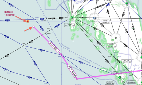
Starting with a set of facts that have been made available publically and verified over the past few days, I first plotted MH370’s course onto an aviation IFR map which shows the airways and waypoints used to navigate the skies. I plotted the point where it stopped transmitting ADS-B information at 1721UTC. I then plotted the Malaysian military radar track from that point towards “VAMPI”, “GIVAL”, and then onward toward “IGREX” on P628 ending with where the plane should be at 1815UTC when military radar lost contact.
More @ Keith Ledgerwood
No comments:
Post a Comment